by Mark Lehner
High-precision measure of the landscape
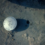
On November 1, 1984, Inspector Amal Samuel, Salah el-Nasar, Abd al Gadar, David Goodman, and I set off across the Maadi Formation ridge that makes up the southern reaches of the Giza Plateau. We carried with us a canvas bag of survey markers, an electric drill, two cans of epoxy, a hammer, a set of punch dye numbers and letters, and a survey notebook.
Our goal was to use precise measuring techniques to create an accurate map of the natural and cultural features of the entire Giza Plateau. This was the genesis of the Giza Plateau Mapping Project (GPMP), an effort to better understand the social and economic forces that supported pyramid construction.
The grid
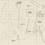
To map a feature on the Giza Plateau and to fix its position relative to any other feature, we needed to establish a control matrix, a Plane Coordinate System: the GPMP grid.
Eleven primary control stations were established at random points that allowed us to sight from one traverse station to its preceding and following traverse stations without obstruction from natural and manmade features (think terrain and pyramids).
This control traverse in the form of an ovaloid-shaped polygon is closed upon itself, allowing adjustment of any error and providing accurate coordinate values of each primary control station.
GPMP grid values are based upon our calculated horizontal center of the Great Pyramid. The arbitrary values of North 100,000 metres and East 500,000 metres were assigned to this calculated center of Khufu’s pyramid. The grid values—so many meters east, and so many meters north—are like streets and avenues for determining the “address” of any point on the plateau.
The GPMP primary control traverse covers the Giza necropolis, spanning the Mokkatam Formation (the Pyramids Plateau proper) and the Maadi Formation, south of the pyramids.
We started at the top of Gebel Qibli (the Southern Mount), the prominent knoll of the Maadi Formation overlooking the wide central wadi (Arabic term for a gulley or dry river bed) south of the Sphinx.
Gebel Qibli is an ideal station for triangulation (the positioning of a point from two or more previously positioned points) and offers a magnificent visual survey of the entire pyramids plateau.
The primary control points
At the top of Gebel Qibli we etched a cross to represent the starting point for our survey: GP1 (Giza Plateau 1).
GP2 is far to the south, on the ridge above a southern wadi. GP3 is beside Covington’s Tomb (an Early Dynastic mastaba tomb) hundreds of meters due south of the Great Pyramid.
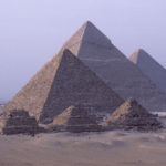
GP3, 4, 5, and 6 are on the Maadi Formation ridge running west towards the place now called the Panorama, where hordes of tourists disembark daily to photograph the three pyramids. Visitors cluster on the foundations of what was once a rest house owned by President Anwar Sadat (1970-1981). We set our point GP6 in the concrete foundations of what must have been Sadat’s bathroom.
The GPMP traverse then runs north-northeast from GP6 to GP7 at the highest part of the Mokkatam Formation. From there we surveyed northeast to GP8, west-northwest of the modern building complex that evolved out of George Reisner’s Harvard Camp (1902-1942). GP9 is on the top of the largest mastaba tomb at Giza, G2000, on line with the north side of the Khufu Pyramid.
From GP9 we sighted down to GP10, set into the bedrock terrace north of the north side of the Great Pyramid. We positioned GP10 to get around the towering mass of the Great Pyramid for a clear line-of-sight to GP9 and GP11.
From GP10 we sighted southeasterly up to GP11 at the top of the southernmost of three queen’s pyramids (GI-c) east of the Great Pyramid. Some 700 meters (2296.5 feet) straight across Giza from GP11, we could then sight directly to our P.O.B—point of beginning (GP1 on Gebel Qibli)—to close our traverse.
The purpose of traversing is to help establish an accurate control network. Traverse points are set in accessible places which (a) minimize any problems due to uneven terrain (b) are visible to previous and following traverse points, and (c) are close to areas of interest.
Thus, a control traverse is what the doctor ordered in weaving around and between any obstacles, be it the Great Pyramid, a modern building, or a natural obstacle.
A gnat’s eyelash
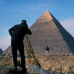
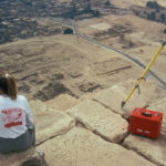
Our next task was to precisely determine the location of each of the traverse points with respect to each other. We measured angles and distances between points with a Leitz Red 2A electronic distance measurer and a Lietz TM1A one-second theodolite.
We made four sets of observations at each station. If the averaged results of a set of four readings differed by more than five seconds of arc from the mean of all four sets, the observation was rejected and observed again. This level of accuracy is called second order by U.S. survey standards. David Goodman called it, “Surveying to a gnat’s eyelash!”
On most days we had a number of tripods and reflectors set up all around the plateau, up to nearly a kilometer (.62 miles) distant, and we would measure a whole series of angles between our occupied station, a reference point, and several secondary or tertiary survey points.
We would do this all in one sweep, with the telescope shooting direct and then with the telescope reversed (180 degrees); a total of four sets each. David Goodman would “run the gun,” (operate the theodolite), while I recorded the data on the survey forms.
In this way, we determined the exact locations of most of our survey points with respect to all the other points.
The angular closure of the primary traverse of almost 6 kilometers (3.7 miles) was only minimal, 0.2 seconds of arc. This tiny error was adjusted throughout the traverse.
Then the horizontal closure was calculated to be 0.0054 metres (0.212 inches) in northing and 0.0156 metres (0.614 inches) in easting. Using those two values the closure was calculated to be 0.0165 metres (0.65 inches).
This yields a closure accuracy of better than one part in 326,750; a gnat’s eyelash for sure.
The single Survey of Egypt monument of record in the area was a brass disk atop the Khufu pyramid. During the second season we coordinated that point by triangulation from GP1 and GP8.
The recorded latitude and longitude of this point are:
N 29° 58’ 44.3830”
E 31° 07’ 57.0194”
(Helmert Spheroid of Reference.)
Now we knew the shape and relative position of our main traverse, our polygon, and a web of auxiliary points. But we did not yet know the orientation of our network with respect to North.
Stellar observations
On the evening of December 31, 1984, David Goodman and I set up the TM1A theodolite at primary control station GP10, just northeast of Khufu’s pyramid. We set a reflector backsight 500 meters (1640.4 feet) west on station GP9, in the northwest sector of the Giza Necropolis.
We took four sets of observations between Polaris (the North Star) and GP9 using a digital watch (synchronized with Universal Time at Greenwich) to record the Greenwich Time at the moment of each sighting.
Using standard ephemeris tables (NAO, 1984), we calculated the azimuth of Polaris at the exact time of each of the sightings. These stellar azimuths were coupled with the observations on GP9 and used to calculate the azimuth from GP10 to GP9. In the same way, azimuths were calculated for our eleven-course closed traverse.
A Bench mark
Calculating the difference in elevation for each of the eleven courses (lines between stations), we closed our survey loop with an accuracy of less than two centimeters (less than 0.78 inches).
The bench mark (a permanent point of known elevation) by which we gauged all elevations in the GPMP grid is in the north face of Khufu’s pyramid, about seventeen meters (55.7 feet) west of the northeast corner and two meters (6.5 feet) plus or minus above the Plateau surface. All GPMP elevations are calculated from the elevation of this single bench mark.
GPMP today
Based on the landscape analysis of the Giza Plateau supported by GPMP survey data, I proposed some likely locations of the city of the pyramid builders (see MDAIK 41, 1985). Beginning in 1988, AERA expanded the mission of the Giza Plateau Mapping Project to excavate and survey those locations. The Lost City of the Pyramid Builders has emerged after 4,500 years of obscurity. We invite you to read about the latest developments in our ongoing work at Giza.

