by Glen Dash
(An excerpt from AERAGRAM 13.2)
No monument in the world has given rise to more speculation about its meaning than the Great Pyramid of Khufu. It has been said to encode “God’s unit of measurement”— the Pyramid inch—to physically represent the mathematical constant pi, and incorporate the Golden Section. Sir Isaac Newton thought it could be used to refine his theory of universal gravitation. All of these ideas, sensible or not, depended to one degree or another on knowing the exact size and orientation of the Great Pyramid. It is surprising then to find that there has been no final, definitive work on the subject. The reason is due, in large part, to the condition we find the Pyramid in today. We find scant traces of its original corners. The best we can do is to project their original positions from the fragmentary data that does remain. It has proven to be a challenge. After Mark Lehner and David Goodman measured the base of the Pyramid in 1984, they set the data aside while Lehner undertook the decades long task of uncovering and mapping the Lost City of the Pyramids. I now return to it.

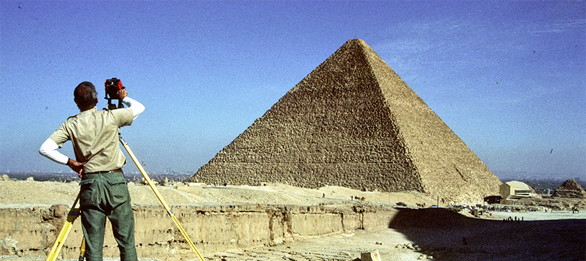
David Goodman surveys in 1984 with a theodolite and electronic distance measuring device to establish the Giza Plateau Mapping Project grid, looking toward the Great Pyramid. Photo by Mark Lehner.
Goodman, a surveyor then with the California Department of Transportation, established the survey grids now used to map both the Giza Plateau and the Valley of the Kings. For this study, he first laid a survey line along each side of the Pyramid between the bronze survey markers left by [Royal Astronomer and surveyor David] Gill, to serve as a control. Lehner then walked along the survey lines, choosing points to measure. When he chose a point, Goodman recorded its distance from one of Gill’s markers electronically. Goodman then sighted along the survey line using his theodolite’s telescope. Lehner laid a tape measure from the point he wished to measure to the survey line, while Goodman, who could see the tape measure in his telescope, recorded the distance between the two. Surveyors refer to these offset measures as “fallings.” At each station, Lehner carefully noted the condition of the edges of the casing and platform stones. Mapping those points where he found the top, outer edge of the platform stones or the lower edge of the casing stones well preserved, I can attempt to reconstruct the original lines of the Pyramid. While previous surveyors had concentrated only on the casing, Lehner measured the platform as well.
In order to analyze this data, I first need to place it on a master grid. The grid I will use is the Giza Plateau Mapping Project (GPMP) control network that was established by Lehner and Goodman in 1984 and 1985. It assigns every point on the plateau coordinates, like addresses for houses on a city map. The origin of the map lies at the calculated center of the Great Pyramid, and everything is measured from that point, in units of meters. Once the Lehner-Goodman data is converted to GPMP coordinates, I can use a standard statistical method known as linear regression analysis to “best-fit” lines to it…
Read this article in its entirety with data charts and visuals, as well as the other featured articles in our AERAGRAM newsletter.
