Archaeological Survey
Era
Old Kingdom – present
Location
Giza Plateau, Saqqara
Project Dates
1984 – present

Map of the Giza pleateau
Mark Lehner and David Goodman launched the Giza Plateau Mapping Project (GPMP) in 1984 to create a high precision map of both the natural and cultural features of the entire Giza Plateau. They literally and figuratively laid the groundwork for all our future work with their creation of a survey control network.
The video to the left explains how we initially set up our survey grid and how our work at AERA began with the Giza Plateau Mapping Project (GPMP).
Starting in 2012, the Glen Dash Foundation Survey (GDFS) began filling in our map of the plateau with a detailed survey of the area’s major monuments. The GDFS surveyed all three major pyramids, their mortuary temples, causeways, queens’ pyramids, quarries and other surviving features in the surrounding areas. At the Great Pyramid, special attention was paid to any traces of the original pyramid casing stones, which helped us to determine the pyramid’s original dimensions, and to the lever sockets, which helped us to document how it was built.
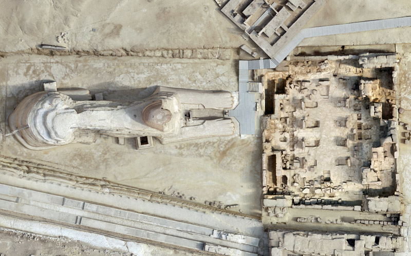
At the Sphinx, the GDFS also did extensive survey work, which the team later built upon with the Return to Sphinx Viewing Project (RSVP) in 2018-2019. The RSVP used both traditional mapping, topographic survey, and ground penetrating radar to document the base of the Sphinx, the Sphinx Temple, and the surrounding areas. In addition, a Japanese team directed by AERA team member Yukinori Kawae recorded the Sphinx area by drone, photogrammetry, and laser scanning to create a complete 3D image of the Sphinx. Read more about all of our work at the Sphinx.
In addition to our ongoing survey work around the plateau, we have also carried out remote sensing at the Lost City site, and laser scanning of the Khentkawes monument and the Step Pyramid in Saqqara. More information about all of these projects can be found in the Selected Bibliography below.
Archaeological Survey Photogallery
A map of the Giza plateau showing both ancient features (in gray) and modern topography (in brown).
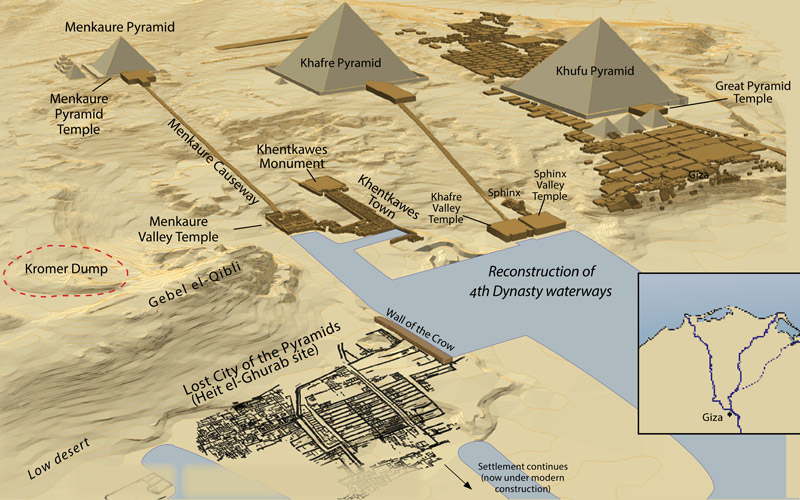
A reconstruction of the ancient monuments, settlements and waterways of the Giza Plateau during the 4th Dynasty.
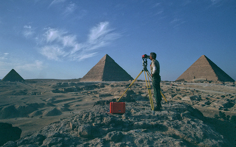
David Goodman setting up the survey grid on the Giza Plateau.
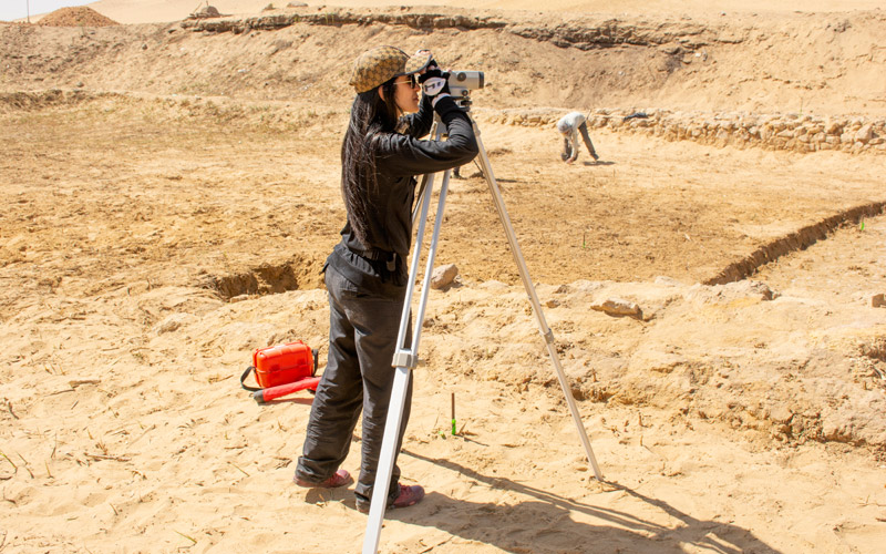
Our beginning field school students are taught the basics of surveying, while advanced survey students are given in-depth training. Here a student is learning to use the transit.
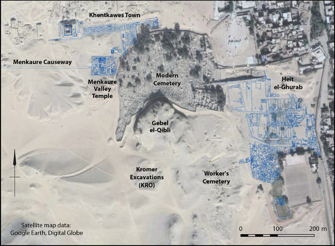
Surveyed and mapped site data superimposed onto satellite imagery of the modern Giza plateau.
A 3D image of the Sphinx and Sphinx Temple from the integrated laser scan data, GoPro video images, and drone images produced by the Japanese Giza 3D Survey team.
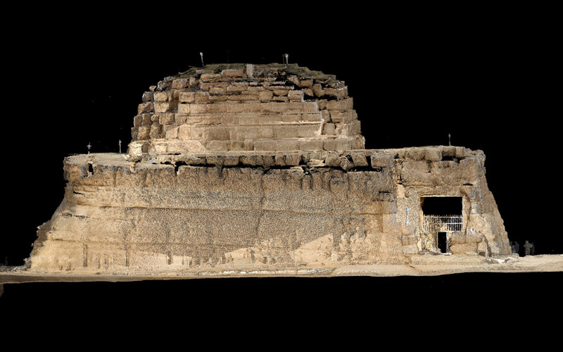
An orthophotographic point cloud image of the south face of the Queen Khentkawes funerary monument, prepared by the Giza Laser Scanning team in 2006.

A PEAKIT image of the Khentkawes monument. This series of images show the four sides and top of the monuent. They were produced by combining multiple images that each represent relief in a different way to help represent the surface relief of the monument more accuately.
Selected Bibliography
2025. Jones, Dan, Sarah Skytte Qvistgaard, and Aurore Ciavatti. “Boat Pits and Builders’ Marks: 3D-Modeling Khufu’s Southern Boat Pits.” AERAGRAM vol 26 no 1-2, pages 18-25.
2025. Sindbæk, Søren and Sarah Skytte Qvistgaard. “Beamoin in on Khafre: The First Laser Survey of the Second Great Pyramid.” AERAGRAM vol 26 no 1-2, pages 3-6.
2024. Sperber, Rebecca D., Dean Goodman, Mark Lehner, and Glen Dash. “Where the Water Disappears: A Ground-Penetrating Radar Survey near the Great Sphinx of Giza.” AERAGRAM vol 25 no 1-2, pages 19-23.
2024. Hawass, Zahi and Mark Lehner. “The Return to the Sphinx Viewing Project.” AERAGRAM vol 25 no 1-2, page 18.
2024. Sindbæk, Søren and Mark Lehner. “The Laser’s Edge: The Great Pyramid South Floor Survey.” AERAGRAM vol 25 no 1-2, pages 3-9.
2024. Lehner, Mark. “Giza Plateau Mapping Project.” Oriental Institute 2023-2024 Annual Report. Edited by Timothy P. Harrison. Chicago: University of Chicago Oriental Institute, pages 33-40.
2024. “Fieldwork 2023-2024: The Great Pyramid Scanning Project.” AERA Annual Report 2023–2024, pages 8-9.
2024. Lehner, Mark. “President’s Message: Foundations from the Past, Building for the Future.” AERA Annual Report 2023–2024, pages 3-4.
2022. Tallet, Pierre, and Mark Lehner. The Red Sea Scrolls: How Ancient Papyri Reveal the Secrets of the Pyramids. London: Thames & Hudson.
2022. Weiss, Daniel. “Journeys of the Pyramid Builders.” Archaeology July/August.
2020. Lehner, Mark. “Lake Khufu: On the Waterfront at Giza Modelling Water Transport Infrastructure at Dynasty IV Giza.” In Profane Landscapes, Sacred Spaces. Edited by Miroslav Bárta and Jiri Janák. Sheffield: Equinox. Pages 191–292.
2020. Lehner, Mark. “Merer and the Sphinx.” In Guardian of Ancient Egypt: Studies in Honor of Zahi Hawass, vol II. Edited by Janice Kamrin, Miroslav Bárta, Salima Ikram, Mark Lehner, and Mohamed Megahed. Prague: Charles University, Faculty of Arts. Pages 895–925.
2018. Dash, Glen. “Where in the World is the Great Pyramid.” AERAGRAM vol 19 no 1, pages 16–20.
2018. Barna, Mark. “Everything Worth Knowing About the Giza Pyramids.” Discover Magazine.
2017. Lehner, Mark, and Zahi Hawass. Giza and the Pyramids: The Definitive History. Chicago: University of Chicago Press.
2017. Lehner, Mark. “David Goodman: Back to the Point of Beginning.” AERAGRAM vol 18 no 2, pages 19-24.
2017. Mutter, George L., Fishman, Bernard P. “Kafr, Village of the Pyramid Sheikhs at Giza.” AERAGRAM vol 18 no 2, pages 10-15.
2017. Dash, Glen. “Occam’s Egyptian Razor: The Equinox and the Alignment of the Pyramids,” Journal of Ancient Egyptian Architecture vol 2, pages 1-8.
2017. Dash, Glen. “Finding Those Indelible Marks Flinders Petrie Left on the Giza Plateau.” AERAGRAM vol 18 no 1, pages 14-17.
2017. “How Egyptians Quarried Their Building Blocks.” AERAGRAM vol 18 no 1, page 7.
2017. Finucane, Martin. “Did the Egyptians create a canal and a port to bring stone to the Great Pyramid?” The Boston Globe.
2017. “New Light on Giza, How the Pyramids built Egypt.” Current World Archaeology vol 86.
2017. Mark Lehner, Megan Flowers, and Rebekah Miracle (Editors). ARCE Sphinx Project 1979-1983 Archive. Released: 2017-11-14. Open Context. https://doi.org/10.6078/M7CZ356B
2016. Dash, Glen, and Joel Paulson. “The 2015 Survey of the Base of the Great Pyramid.” Journal of Egyptian Archaeology vol. 102, pages 186–195.
2016. Dash, Glen, and Mark Lehner. “Scanning by Eye and Experience: In Search of the Human Hand That Built the Great Pyramid,” AERAGRAM vol 17 no 1 & 2, pages 20–23.
2015. Dash, Glen. “The Great Pyramid’s Footprint: Results from Our 2015 Survey.” AERAGRAM vol 16 no 2, pages 8–14.
2015. Dash, Glen. “What Was the Original Size of the Great Pyramid’s Footprint?” AERAGRAM vol 16 no 1, pages 8–11.
2015. “Glen Dash Foundation Great Pyramid Survey.” AERA Annual Report 2014–2015, page 7.
2015. Still, Alexander. “The World’s Oldest Papyrus and What It Can Tell Us About the Great Pyramids.” Smithsonian Magazine.
2015. Zorich, Zach. “How Egypt’s Great Pyramid Changed Civilization.” Scientific American.
2014. Lehner, Mark. “On the Waterfront: Canals and Harbors in the Time of Giza Pyramid-Building.” AERAGRAM vol 15 no 1 & 2, pages 14–23.
2014. Dash, Glen. “Did Egyptians Use the Sun to Align the Pyramids?” AERAGRAM vol 15 no 1 & 2, pages 24–28.
2013. Kawae, Yukinori. “PEAKIT Punches Up 3D Laser Scanning, Adds Accurate Surface Relief.” AERAGRAM vol 14 no 2, pages 2–4.
2013. Dash, Glen. “How the Pyramid Builders May Have Found Their True North.” AERAGRAM vol 14 no 1, pages 8–14.
2012. Dash, Glen. “New Angles on the Great Pyramid.” AERAGRAM vol 13 no 2, pages 10–19.
2012. “Glen Dash Foundation Survey: Data for the Fist Accurate Archaeological Map of the Giza Plateau.” AERA Annual Report 2011–2012, pages 22–24.
2012. Dash, Glen. “North by Northwest: The Strange Case of Giza’s Misalignments.” AERAGRAM vol 13 no 1, pages 10–15.
2012. “GPMP Full Circle,” AERAGRAM vol 13 no 1, pages 16–19.
2011. Tavares, Ana. “Coordinate Systems and Archaeological Grids Used at Giza.” In Giza Reports, Vol 1. Edited by Mark Lehner and Wilma Wetterstrom. Boston: Ancient Egypt Research Associates. Pages 203–216.
2011. Miracle, Rebekah. “Something Old, Something New, Something Borrowed in Map View: GIS Brings It All Together.” AERAGRAM vol 12 no 2, pages 10–12.
2011. Dash, Glen. “Solar Alignments at Giza.” AERAGRAM vol 12 no 2, pages 3–9.
2009. Kawae, Yukinori, Kosuke Sato, Hiroyuki Kamel, Tomoaki Nakano, and Ichiroh Kanaya. “Saqqara Laser Scanning Survey 2008.” In Giza Occasional Papers, Vol 4: Season 2008 Preliminary Report. Edited by Mark Lehner. Boston: Ancient Egypt Research Associates, pages 63-71.
2009. Lehner, Mark. “Capital Zone Walk-About 2006: Spot Heights on the Third Millennium Landscape.” In Giza Occasional Papers, Vol 3: Seasons 2006-2007. Preliminary Report. Edited by Mark Lehner, Mohsen Kamel and Ana Tavares. Boston: Ancient Egypt Research Associates. Pages 97-151.
2009. Dash, Glen. “2006 Geophysical Season at Giza: A Ground-Penetrating Radar Study.” In Giza Occasional Papers, Vol 3: Seasons 2006-2007. Preliminary Report. Edited by Mark Lehner, Mohsen Kamel and Ana Tavares. Boston: Ancient Egypt Research Associates. Pages 152-157.
2009. Bunbury, Judith, Catherine (Katy) Lutley, and Angus Graham. “Giza Geomorphological Report.” In Giza Occasional Papers, Vol 3: Seasons 2006-2007. Preliminary Report. Edited by Mark Lehner, Mohsen Kaeml and Ana Tavares. Boston: Ancient Egypt Research Associates. Pages 158-165.
2009. Kawae, Yukinori. “Giza Laser Scanning Survey 2006.” In Giza Occasional Papers, Vol 3: Seasons 2006-2007. Preliminary Report. Edited by Mark Lehner, Mohsen Kamel and Ana Tavares. Boston: Ancient Egypt Research Associates. Pages 166-176.
2008. Lehner, Mark. The Complete Pyramids. London: Thames & Hudson.
2008. Lehner, Mark. “Giza Overviews and Ground Truths.” AERAGRAM vol 9 no 2, pages 14–15.
2008. “Saqqara Laser Scanning Survey 2008.” AERA Annual Report 2007–2008, pages 22–25.
2008. “Geographical Information System.” AERA Annual Report 2007–2008, pages 5–7.
2007. Kawae, Yukinori. “Mapping Khentkawes.” AERAGRAM vol 8 no 2, pages 10–12.
2007. Goodman, David. “The GPMP Survey and Mapping Control Datum.” In Giza Reports, Vol 1. Edited by Mark Lehner and Wilma Wetterstrom. Boston: Ancient Egypt Research Associates, pages 98–101.
2007. Goodman, David, and Mark Lehner. “The Survey: The Beginning.” In Giza Reports, Vol 1. Edited by Mark Lehner and Wilma Wetterstrom. Boston: Ancient Egypt Research Associates, pages 53–95.
2004. Dash, Glen. “Seeing Beneath the Surface.” AERAGRAM vol 7 no 1, pages 1, 6–10.
2002. “Giza As Is: Unfinished Business Reveals the Human Hand.” AERAGRAM vol 5 no 2, page 1.
2002. Lehner, Mark. “The Fabric of a Pyramid: Ground Truth.” AERAGRAM vol 5 no 2, pages 4–5.
2001. Butzer, Karl W. “When the Desert Was in Flood: Environmental History of the Giza Plateau.” AERAGRAM vol 5 no 1, pages 3-5.
2001. Bonani, George, Hebert Haas, Zahi Hawass, Mark Lehner, Shawki Nakhlas, John Nolan, Robert Wenke, Willy Wolfi. “Radiocarbon Dates of Old and Middle Kingdom Monuments in Egypt.” Near East Chronology: Archaeology and Environment. Proceedings of the 17th International Conference. Edited by Hendrik J Bruins, I Cami, and E. Boaretto. Radiocarbon, vol 43, no. 3. Pages 1297–1320.
2000. Dash, Glen. “Giza Ground Truth: Magnetic Anomaly Surveying.” AERAGRAM vol 4 no 1, pages 9-11.
2000. Lehner, Mark. “Fractal House of Pharaoh: Ancient Egypt as a Complex Adaptive System, a Trial Formulation.” In Human and Primate Societies: Agent-Based Modeling of Social and Spatial Processes. Edited by Timothy A. Kohler and George J Gumerman. Santa Fe Institute: Studies in the Sciences of Complexity. New York: Oxford University Press. Pages 275–353.
2006. “The Pyramids Radiocarbon Dating Project.” AERAGRAM vol 1 no 1, pages 10–11.
1999. Nakhla, S, Zahi Hawass, Willy Wolfi, Herbert Haas, Mark Lehner, Robert Wenke, Wilma Wetterstrom, and Geörg Bonani. “Dating the Pyramids.” Archaeology Sep/Oct, vol. 52, Issue 5, pages 26–33.
1999. Lehner, Mark. “Construction of Pyramids (Old Kingdom).” In Encyclopedia of the Archaeology of Ancient Egypt. Edit by Kathryn A. Bard. London and New york: Routledge. Pages 639–646.
1998. Lehner, Mark. “Niches, Slots, Grooves and Stains: Internal Frameworks in the Khufu Pyramid?” Stationen: Beitrage zur Kulturgeschichte Agyptens Rainer Stadelmann gewidmet. Edited by Heike Guksch und DanieJ Polz. Mainz: Verlag Philipp von Zabern. Pages 101–113.
1997. Lehner, Mark. End of Field Season Full Report. PBS Nova Online Adventure.
1996. Lehner, Mark. “The Pyramid.” Secrets of Lost Empires, by Michael Barnes, Robin Brightwell, Adriana von Hagan, Mark Lehner, and Cynthia Page. London: BBC Books. Pages 47–93.
1996. Lehner, Mark, and David Goodman. “New Mapping of Ancient Egypt.” POB February, vol. 21, no 3, pages 16–24.
1987. Haas, Herbert, James Devine, Robert Wenke, Mark Lehner, Willy Wolfli, and Geörg Bonani. “Radiocarbon Chronology and the Historical Calendar in Egypt.” BAR International Series, vol.379 (II), pages 585–606.
1986. Lehner, Mark, and David Goodman. “Unraveling the Mystery of Pyramid Construction.” POB April–May, vol 11, no 4, pages 12–19.
1986. Lehner, Mark. “The Giza Plateau Mapping Project: Season 1986.” Newsletter of the American Research Center in Egypt, no. 135, pages 29–48.
1985. Lehner, Mark. “The Development of the Giza Necropolis: The Khufu Project.” Mitteilungen des Deutschen Archäologischen Instituts. Abteilung Kairo, vol 41, pages 109–143.
1985. Lehner, Mark. “Giza Plateau Mapping Project: Season 1984–85.” American Research Center in Egypt Newsletter, no 131, Fall, pages 23–56.
1985. Lehner, Mark. “Giza: A Contextual Approach to the Pyramids.” Archive für Orientforschung vol 32, pages 136–158.
1985. Lehner, Mark. “The Pyramid Tomb of Hetep-Heres and the Satellite Pyramid of Khufu.” Deutsches Archaologisches Institut Abteilung Kairo 19. Mainz: P Von Zabern.
1983. Lehner, Mark. “Some Observations on the Layout of the Khufu and Khafre Pyramids.” Journal of the American Research Center in Egypt vol. 20, pages 7–25.